In the year 2028, the landscape of tribal land rights has undergone a remarkable transformation, largely due to the integration of advanced satellite imagery technology with traditional knowledge mapping. This article explores the intersection of these two methodologies and their implications for the protection and advocacy of tribal land rights.
The advent of AI has revolutionized the way we perceive and utilize satellite imagery. High-resolution satellite data, combined with AI algorithms, has provided unprecedented insights into the land use patterns, resource distribution, and environmental changes affecting tribal territories. This technological prowess has become a powerful tool for tribes to assert their land rights and to protect their ancestral lands.

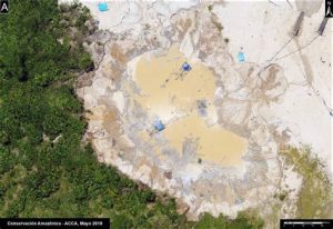
Satellite Imagery: A Window into the Ancestral Land
Satellite imagery offers a bird’s-eye view of the earth’s surface, capturing detailed information about land cover, topography, and land use. In the context of tribal land rights, satellite data has proven to be invaluable for several reasons:
1. Verification of Land Claims: Tribes can use satellite imagery to verify their land claims by demonstrating historical land use patterns, identifying culturally significant sites, and establishing the extent of their ancestral territories.
2. Monitoring Environmental Changes: Satellite data allows tribes to monitor environmental changes such as deforestation, land degradation, and climate change impacts on their lands. This information can be used to advocate for conservation measures and sustainable land management practices.
3. Documentation of Land Rights: High-resolution satellite imagery can serve as a legal and historical record of land use and ownership, providing a strong foundation for tribal land rights advocacy and legal battles.
Traditional Knowledge Mapping: The Heart of Cultural Identity
While satellite imagery provides a comprehensive view of the physical landscape, traditional knowledge mapping delves into the cultural and historical dimensions of tribal land rights. This method involves the use of oral histories, stories, and maps passed down through generations, capturing the spiritual, social, and economic aspects of land stewardship.
1. Cultural Significance: Traditional knowledge mapping highlights the cultural significance of specific sites, sacred places, and resource areas, ensuring that these elements are recognized and protected.
2. Resource Management: By understanding the traditional practices and beliefs surrounding land use, tribes can develop sustainable resource management strategies that are in harmony with their cultural heritage.
3. Strengthening Community Bonds: Traditional knowledge mapping fosters a sense of community and shared identity, as members of the tribe work together to preserve and promote their cultural heritage.
The Synergy of AI and Traditional Knowledge Mapping
In 2028, the synergy between AI-driven satellite imagery and traditional knowledge mapping has led to a more robust approach to tribal land rights advocacy. This integration has several benefits:
1. Enhanced Accuracy: By combining the precision of satellite data with the cultural insights of traditional knowledge mapping, tribes can present a more accurate and comprehensive picture of their land rights claims.
2. Broader Community Involvement: The collaboration between AI and traditional knowledge mapping encourages broader community involvement in land rights advocacy, ensuring that diverse perspectives are considered.
3. Strengthened Legal Position: The combined approach provides a stronger legal foundation for tribal land rights claims, making it easier for tribes to navigate the complexities of land tenure and legal battles.
In conclusion, the year 2028 has witnessed a remarkable fusion of AI-driven satellite imagery and traditional knowledge mapping in the realm of tribal land rights. This innovative approach has empowered tribes to protect their ancestral lands, preserve their cultural heritage, and ensure sustainable resource management for future generations. As the world continues to evolve, the fusion of technology and tradition will undoubtedly play a crucial role in shaping the future of tribal land rights.